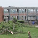
The National Weather Service confirmed a tornado touched down in Revere, Massachusetts, shortly after 9 o’clock Monday morning. There are reports of partial building and roof collapses, downed trees and power lines. The storm was the latest to hit the region in the past couple of days that also produced a tornado funnel cloud over Springfield.
National Weather Service meteorologist Kim Buttrick says a funnel cloud – basically a tornado aloft – was sighted early Sunday afternoon near Interstate 291 in Springfield, moving east towards Ludlow before it dissipated and lifted back up into the cloud. But unlike the storm in Revere, the funnel did not trigger a severe weather warning, which Buttrick says is determined by a number of factors.
“We look at the winds in the thunderstorm; we look at the updrafts; we look at how much rain that’s in the storm. All these things factor in, and everything kind of has to come together on whether or not we’re going to issue a warning.”
Buttrick says reports of damage associated with the funnel cloud were limited to a large tree limb knocked down and an awning blown off a roof that damaged a car. By contrast, thunderstorms that rolled in later Sunday caused much more damage and thousands of power outages across western Massachusetts.
The weather service says this round of storms will wrap up tonight. That’s because a low pressure system from the west will move into the area overnight, bringing relatively cooler and drier conditions.